

Resort Map

Main Level Sites
Heliport, Cabins 1-26, Backbone Company Store, Tipple Tavern, & Pool
Cabin, 45 & 46 located on Trail 59
%20copy.png)

Upper Level Sites
Upper Cabins (C27-C44)
.png)


RV Sites
RV Sites & Bath House Locations


Camping Sites
Primitive Camping, Trail Shelters, & Deluxe Tents
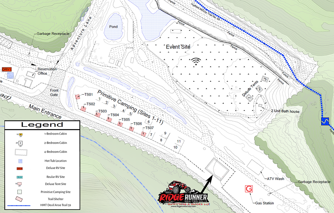
Trail Shelters 1-7

DRIVING DIRECTIONS
WRITTEN DIRECTIONS ARE STRONGLY RECOMMENDED!
IMPORTANT INFORMATION ABOUT DIRECTIONS:
-
Our address is 100 Adventure Lane, Matewan, WV 25678.
-
Please be aware that some guests have had issues using our physical address.
-
Make sure the address says Matewan, WV and not Man, WV (Apple Maps especially seems to have this issue)!
-
An alternate address to use for GPS is the Red Jacket Postal Service, 1 Mate Creek Rd, Red Jacket, WV 25692. The resort entrance is exactly 2.1 miles east of the Red Jacket Post Office on Mate Creek Road.
-
Please note that GPS directions will likely not be accurate or provide the best route for large vehicles. Please rely on the directions provided below for the best route.
-
-
When you arrive, a GATE CODE IS REQUIRED to enter the property. If you do not receive this code via text the day prior to check in, please CONTACT US.
-
Please note this is a rural area and cell phone service and internet connection may be limited when you arrive. Please have your site information and gate code available in case you have issues contacting the resort.
FROM CHARLESTON:
TAKE 119 SOUTH (APPROXIMATELY 70 MILES) TO WV 65 SOUTH
IN 7.7 MILES, WV 65 SOUTH MERGES WITH WV 52
AT TAYLORVILLE, TURN RIGHT ONTO WV 65 SOUTH
TURN LEFT ONTO CO. ROUTE 6 (MATE CREEK ROAD)
CONTINUE ON MATE CREEK ROAD 2.6 MILES
WE ARE 2.1 MILES EAST OF THE RED JACKET U.S. POST OFFICE ON THE LEFT
FROM WILLIAMSON:
TAKE 119 TO WILLIAMSON.
PROCEED THROUGH WILLIAMSON FOLLOWING THE TRUCK ROUTE:
TURN ONTO HARVEY STREET
TURN LEFT ONTO W 2ND AVE
TURN RIGHT ONTO PRICHARD ST, CROSS RAILROAD TRACKS
TURN RIGHT ON FOURTH AVE/US 52
PROCEED SOUTH ON 4TH AVE./ROUTE 52 (11.5 MILES)
TURN RIGHT ONTO WV-65 S (2.5 MILES)
TURN LEFT ONTO MATE CREEK RD
WE ARE APPROXIMATELY 2.6 MILES ON THE LEFT
FROM MATEWAN:
TURN LEFT ONTO 65 N
PASS GIOVANNI'S
TURN RIGHT ONTO ROUTE 6 (MATE CREEK ROAD)
WE ARE 2.1 MILES EAST OF THE RED JACKET U.S. POST OFFICE ON THE LEFT
FROM GILBERT:
52 W TO HORSEPEN MOUNTAIN
TURN LEFT ONTO 44 AT MARATHON STATION (ON HORSEPEN MOUNTAIN)
TURN RIGHT ONTO KING COAL HIGHWAY (ROUTE 52)
TURN LEFT ONTO 65
TURN LEFT ONTO ROUTE 6 (MATE CREEK ROAD)
WE ARE 2.1 MILES EAST OF THE RED JACKET U.S. POST OFFICE ON THE LEFT
If these towns are not listed, please use the alternate address below. We’re 2.1 miles east of the below address (you will see Devil’s Backbone Adventure Resort signs ¼ mile before and at the entrance).
Red Jacket U.S. Post Office
1 Mate Creek Road
Red Jacket, WV 25692
We suggest consulting www.wv511.org prior to your trip. It will provide current information on road conditions and closures that may affect or impede travel.